Recogido de Mundogeo:
http://www.mundogeo.com.br/noticias-diarias.php?id_noticia=15716&lang_id=2
Esri España aporta sistemas de información geográfica al programa de Jesús Calleja
17/12/2009
Zanskar, la productora de “Desafío en Himalaya”, el nuevo programa de aventuras de Jesús Calleja en Cuatro Tv, ha llegado a un acuerdo con ESRI España, la compañía de sistemas de información geográfica, para incorporar las herramientas GIS en las labores de edición y producción de la serie.
El aventurero reseña que una las mayores dificultades con que tropieza en algunos de sus viajes es la ausencia de mapas de los lugares de destino, por tratarse de sitios recónditos e inexplorados.
viernes, 18 de diciembre de 2009
martes, 24 de noviembre de 2009
Curso Nacional de AIKIDO, en Daganzo de Arriba, Madrid

Jesus Vazquez Huete: Este fin de semana se imparte un curso de AIKIDO, por Ricardo Ledesma, en Daganzo de Arriba, al Noreste de Madrid, en el Polideportivo Municipal. Lo podéis ver en la página del calendario del AIKIKAI. Os dejo el enlace. Sabado 28 y domingo 29 de Noviembre.
El que pueda, estaremos encantados de recibiros, para los que no ya os iré contando algo.
Saludos
domingo, 15 de noviembre de 2009
Herramienta de gestión de Redes Tivoli, Netview
NetView® de Tivoli, una herramienta de administración de redes líder en el mercado corporativo y para proveedores de servicios. NetView® de Tivoli ofrece a los administradores de redes una importante solución capaz de ordenar grandes cantidades de información en un período muy corto de tiempo. Asimismo, captura los datos que resuelven los problemas de la red, dando lugar a soluciones rápidas y la alta disponibilidad de los sistemas que requiere una empresa.
......
......
viernes, 2 de octubre de 2009
"De camino a la universalización de los sistemas GIS" Por fin una globalización tematica y de conocimiento
Hola amigos y compañeros,
Posteo este link, ya que me parece el más adecuado, sobre la nota de prensa de ESRI España para su conferencia 09.
Creo que después de un duro y largo trabajo, por cuenta de todos los expertos en GIS tanto de casas tecnológicas, como de propuestas libres y/o educativas.
Junto al "empujoncito" que nos dío Google "Maps y Earth". El ciudadano de a pie sabe que existe esta CIENCIA, y empieza a comprender para que sirve.
Creo que estamos de celebración.
Saludos
sábado, 8 de agosto de 2009
Primeras novedades de ArcGIS 9.4 por James Fee
1. There is no Crystal Report Wizard in ArcGIS, the only means for creating a report is based on our new reporting engine.
2. The Wizard is entirely new and includes options for the layout (default positioning of groups, summary stats, records, header, footer) and style of the report.
3. Styles (templates as you call them) are new at 9.4, and you have the ability to create custom styles. Much easier to create a professional looking report.
4. There is a Report Designer, where you can easily and interactively design the look and feel of the report layout; easily place graphics and other elements on the report.
5. You can export the report out to more formats, including html, xls, pdf to name a few.
6. The new reporting tools are a complete upgrade in terms of performance and usability. They are simply easy to work with; as one would expect.
7. The biggest improvement in functionality is the ability to load/run a report. At 9.3.1 every report you created was static, you could not open it up to edit it or generate the same report with updated attributes or selections. At 9.4, you can load or run an existing report to make changes or see the changes within your data without having to start from scratch.
viernes, 7 de agosto de 2009
3D para la API for Flax de Google Maps

La mejor forma de simular un 3D, desde un 2D en Google Maps, con el API para Flax.
Google Maps API for FLash añade un modo 3D
Google ha lanzado un nuevo modo de perspectiva 3D para aplicaciones creadas con Google Maps API for Flash. Con el, los usuarios podrán moverse en los mapas 2D pero como si estos realmente tuvieran 3D.
Así, al estilo de Google Earth, se podrá rotar el mapa y volar en el. También podemos hacer zoom contínuo si mantenemos pulsado el botón de “+”, y podemos ver un gran avance aquí puesto que el movimiento que han logrado es bien suave.
Aunque no tan poderoso como utilizar el plugin de Google Earth para navegadores, Google Maps API for Flash tiene una ventaja indiscutida y es el hecho de que Flash es una tecnología hoy día casi omnipresente. En el artículo de la fuente, los desarrolladores explican como hacer uso de estas nuevas posibilidades, junto con varios ejemplos que las demuestran
jueves, 6 de agosto de 2009
MapIt - La unión entre el software y los servicios Online, en los SIG de ESRI

July 13, 2009
ESRI MapIt Correlates Your Business Data with Maps
Mapping Application Combines Software and Services to Unlock the Spatial Component in Enterprise Data
Redlands, California—Businesses have an exciting new tool to gain insight into their business operations with ESRI MapIt. A new software product from ESRI, the market leader in geographic information systems (GIS), MapIt combines software with services to enable businesses to create maps displaying their enterprise data. MapIt software transforms the static spreadsheet and tabular data that managers typically view into dynamic information displayed on vibrant maps.
MapIt is designed to work on the Microsoft application platform, which enables organizations to create visually rich mapping applications using the skills and infrastructure they already possess. It includes all components needed to quickly begin mapping enterprise data from Microsoft SQL Server 2008 and Microsoft Office Excel. Maps can be displayed in rich, interactive applications using Microsoft Silverlight or Windows Presentation Foundation (WPF) or in Microsoft SharePoint Server 2007.
Since MapIt is developed by ESRI, users have access to a wealth of online services to extend and enhance their maps. These services encompass street and imagery basemaps from Bing Maps for Enterprise and ArcGIS Online; geocoding and optimized routing services; demographic and customer segmentation data; and much more.
"MapIt is the result of a close collaboration with Microsoft," says Jack Dangermond, ESRI president. "It is a new mapping product for business intelligence that fits well with the IT infrastructure. We believe it will change the analytic environment for enterprise data by adding a spatial dimension in a highly visual framework."
Organizations using MapIt can answer questions about their data to improve their business decisions, such as, Where are my most profitable customers located? and How can my salespeople maximize their efforts while in a targeted region? These are questions that can be quickly answered when analyzing the information on a map. The MapIt built-in geocoder transforms addresses, ZIP Codes, provinces, and any other information that refers to a place into geographic coordinates.
Microsoft business partners, like E•SPONDER, LLC, are already adopting and developing solutions with MapIt. E•SPONDER is a market leader in creating software solutions for managing emergency situations and is using MapIt to dynamically display this critical information on a map for its customers. "Using MapIt and Microsoft technology, we reduced our development costs and delivered a new product in record time," says Mark Seward, vice president of software development, E•SPONDER.
ESRI and Microsoft presented MapIt during the keynote at the Microsoft Worldwide Partner Conference in New Orleans, Louisiana. In addition, E•SPONDER will be presenting its solution built using MapIt in another keynote on Wednesday, July 15, 2009.
MapIt is now available for purchase. An evaluation version is also available as a free download. For more information or to evaluate MapIt, visit www.esri.com/mapit.
lunes, 13 de julio de 2009
Disculpas para mis lectores

Disculpar queridos amigos que durante un tiempo no he publicado nada nuevo en Mi Blog, pero estoy disfrutando de un periodo de descanso, dentro de poco y pudiendo reciclarme en otros productos y herramientas GIS, muy populares, volveré a compartir mis experiencias con todos vosotros.
Por ahora, me voy de vacaciones con la familia.
Saludos a todos.
miércoles, 20 de mayo de 2009
Ya está disponible la versión 8 de ArcPAD
Bueno después de ir apareciendo las novedades y bondades de la nueva versión del primer producto móvil para la edición en campo de la tecnología ArcGIS, por fin ya lo tenemos disponible en el mercado español:
Descárgate el PDF con todas las novedades
También, dentro del canal en YouTube de ESRI España, podéis encontrar un video-demo, de las novedades de esta versión, totalmente en "Castellano":
Descárgate el PDF con todas las novedades
También, dentro del canal en YouTube de ESRI España, podéis encontrar un video-demo, de las novedades de esta versión, totalmente en "Castellano":
Espero que sea de vuestro interés.
Saludos desde Madrid - España.
martes, 12 de mayo de 2009
Me preguntan por la disponibilidad de ArcGIS Explorer 900
Buenas a todos, Como bien podéis comprobar en la página oficias de ESRI Inc.
ArcGIS Explorer 900 aún no está en el mercado, aunque podemos ir mirando cuales son sus novedades en este vídeo:
Para los Hispano-Hablantes que no puedan o quieran estar leyendo en Ingles, os paso el enlace a la página de producto de ESRI España:
http://www.esri.es/index.asp?pagina=494
Espero haber sido de ayuda, recibir un saludo a todos.
jueves, 7 de mayo de 2009
Tres Podcast en un solo Post - ArcGIS y Mercados
2009 Highlights de la Developer Summit de ESRI
Rob Elkins, Developer Group product manager de ESRI, resume las principales acciones de la Cumbre de Desarrolladores de ESRI 2009 en Palm Springs California.
Novedades en el Servidor ArcGIS Server 9.3.1
Ismael Chivite, antiguo compañero de ESRI España y actual Product Manager de ArcGIS Server en ESRI Inc, proporciona una introducción a las mejoras que traerá la próxima versión 9.3.1 de ArcGIS Server.
Hoy crear franquicias satisfactoriamente se puede realizar utilizando los GIS
Simon Thompson, commercial business industry solutions director de ESRI Inc, habla del papel de los GIS en el optimo franquiciamiento y las diferentes soluciones que ESRI proporciona para ayudar a los negocios que buscan a ampliarse o encontrar un lugar optimo.
miércoles, 6 de mayo de 2009
Using Dojo to Enhance Web Mapping Applications « GeoChalkboard

Using Dojo to Enhance Web Mapping Applications « GeoChalkboard
ESRI and Dojo
The ArcGIS Server JavaScript API, released with ArcGIS Server 9.3, sits directly on top of Dojo providing developers with access to Dojo user interface widgets and all the other benefits of Dojo core through a simple reference in your web application.
Since Dojo is included with the ArcGIS JavaScript API you do not need to reference the Dojo API to get access to its functionality. When you include the following references to the ArcGIS Server JavaScript API, you also get access to the full Dojo toolkit. There is no need to download, host, or even reference the Dojo API.
lunes, 4 de mayo de 2009
Questions and answers about ArcGIS Server 9.3.1 map services

Seguimos con las novedades de la versión 9.3.1.
Donde ahora os paso del Blog de desarrolladores de ArcGIS Server de ESRI Inc. las respuestas a preguntas frecuentes sobre los servicios de Mapa de ArcGIS Server en esta versión.
n a previous post Design patterns for Web maps, we talked about strategies and challenges for displaying different types of map layers on the Web for the best performance. Caching is the fastest way to serve Web maps, but requires an initial time investment for cache creation. Also, datasets that change often and cover a broad extent cannot be cached and require a (typically slower) dynamically drawn service.
ArcGIS Server 9.3.1 addresses some of these performance challenges through a new drawing engine, developed for rendering ESRI map services as fast as possible. The faster dynamic drawing in 9.3.1 can speed up your dynamic map services that cannot be cached due to their oft-changing nature. It can also shorten the tile creation time for cached services.
All map services begin with a map document (MXD) that you create in ArcMap. A new toolbar in ArcMap, the Map Service Publishing Toolbar, does two things to help improve your map’s performance.
First, the toolbar helps you analyze your MXD for potential performance issues. At this stage you can identify bottlenecks that may not be directly related to the drawing engine. These could be things such as missing spatial and attribute indexes, or layers projecting on the fly.
Second, the toolbar gives you a way to create a map service definition (MSD), which is a new file type that works with the optimized drawing engine. The diagram below shows that either an MSD or an MXD can be published as a map service. In this post we’ll talk about when you would use each file type.
The rest of this article answers common questions about the 9.3.1 MSD-based map service and its related functionality.
What aspects of drawing are improved with the MSD-based map service?
First of all, it’s faster. With MSD-based services, complex symbology does not impose the same performance burden that it does with MXD-based services. Your maps should draw at speeds comparable to or faster than similar ArcIMS maps.
MSD-based services also support anti-aliasing which smoothes the edges of lines and text. This is something that was previously available only in cached map services (with a significant performance cost during cache creation). Anti-aliasing with MSD-based services is available over a range of quality levels, allowing you to get the visual benefits while maintaining control over performance. You also have the option to apply the anti-aliasing to the text only.
The quality of map images return by the MSD-based service is also superior to previous versions. MSD-based services produce less “salt and pepper” dithering because the PNG 8 and GIF palettes are chosen using the 256 most frequently-used colors in the map. Also, with PNG 32 services, true transparent values are used in the anti-aliasing, which means you won’t see artifacts from the background color.
What is the MSD file and can I edit it?
The map service definition (MSD) file is a new file used by the fast map service drawing engine introduced at ArcGIS Server 9.3.1. The MSD file always starts with an MXD map document. You use the Map Service Publishing Toolbar to analyze your MXD in ArcMap. Once you’ve addressed issues returned by the analysis, you use the same toolbar to either publish the service or save the MSD file.
ArcGIS Server is the only application that can read the MSD file.
Where is the MSD file created when I publish a service from the Map Service Publishing Toolbar?
When you publish a service using the Map Service Publishing Toolbar, an MSD file is created in your ArcGIS Server input directory. This is a new directory at 9.3.1 that is registered with ArcGIS Server as the default location of your MSD files. In a one-machine deployment, it’s located by default at c:\arcgisserver\arcgisinput.
The toolbar also allows you to save your MSD file to other locations.
Do I need to be an administrator to publish map services with the Map Service Publishing Toolbar?
You need to be a member of the agsadmin group on the GIS server in order to publish map services from the Map Service Publishing Toolbar. If you’re not a member of agsadmin, you should save the MSD in a location where the server administrator can access and publish it.
If I make changes to the MXD, do I have to create the MSD again?
Yes. Once you save an MSD file, it is no longer connected with its parent MXD. If you edit the MXD, you need to use the Map Service Publishing Toolbar to save an updated MSD. Once you’ve overwritten the old MSD, restart the map service to register the changes.
What capabilities (server object extensions) are supported for MSD-based map services?
The WMS and KML capabilities are available with MSD-based services, as well as the default Mapping capability. Custom server object extensions can also work with MSD-based services but they cannot access fine-grained ArcObjects; they must use the coarse-grained methods on MapServer and its related classes.
At 9.3.1 can I still publish an MXD as a map service?
Yes. You can still publish an ArcMap document (MXD) as a service. The service will not use the new drawing engine introduced at 9.3.1; it will use the traditional drawing engine from ArcGIS Server versions 9.3 and previous.
Can I cache an MSD-based service?
Absolutely. Cache tiles get created more quickly with an MSD-based service. Also, anti-aliasing works better with caching when you use MSD-based services. The anti-aliasing occurs faster than it does with MXD-based services, and you can control the level of anti-aliasing on both features and text.
What layer types are supported by the MSD-based map service?
The MSD-based map service supports the most commonly-used feature layers and rasters. Exceptions, such as CAD layers or TINs, should be placed in a separate, MXD-based map service. The Map Service Publishing Toolbar will log errors for any layers in your map document that would prevent you from publishing an MSD-based service.
What else is available / not available in MSD-based services?
The ArcGIS Server 9.3.1 Help topic Supported functionality in MSD-based map services contains a full list of layers, symbology, and functionality available in MSD-based map services. All symbols are available with the exception of chart symbols, representations, and 3D symbols. The Maplex labeling engine is not available.
How am I supposed to use MSD-based services if Maplex isn’t supported?
Use annotation layers, which are supported in MSD-based map services. Annotation gives you the benefit of the Maplex label placement without the server having to make computationally intensive label placement decisions on every map request. Creating cache tiles from the annotated map will cause the service to run even faster.
If you can’t make annotation and you need Maplex, your next best option for performance is to create a cache from an MXD-based service.
When publishing raster datasets, should I use MSD-based map services or should I use the ArcGIS Server Image extension?
In most circumstances, it’s faster to serve rasters through the ArcGIS Server Image extension instead of through map services (whether cached or dynamic). A cached map service may be a more scalable solution if your service will receive many hits at once, but a cache requires creation and maintenance of tiles. MSD-based services will speed up the tile creation if you decide to use a cached service.
When should I use anti-aliasing?
Choose anti-aliasing when you are creating a production-quality map for an Internet audience. Anti-aliased images have become a standard for Web 2.0 map appearance.
Be aware that high levels of anti-aliasing can slow performance. Use the Preview button on the Map Service Publishing Toolbar to get an idea of the visual and performance effects of the anti-aliasing. If the dynamic anti-aliasing is not fast enough, you can lower the quality of the anti-aliasing or you may consider caching the service.
What licensing do I need in order to use the Map Service Publishing Toolbar?
The Map Service Publishing Toolbar is available at all license levels of ArcGIS Desktop (ArcView, ArcEditor, and ArcInfo). You can use the toolbar to analyze and improve the performance of your map documents even if you won’t be publishing an MSD-based map service.
Podcast: What's New in ArcGIS Server 9.3.1
Ismael Chivite, ArcGIS Server product manager, provides a preview of the enhancements in the upcoming release of ArcGIS Server 9.3.1. Chivite highlights the faster dynamic map services, new tools to author and publish optimized map services, and a new developer API, the ArcGIS API for Microsoft Silverlight.Pincha aquí par escucharlo.
jueves, 30 de abril de 2009
Bueno Señores creo que por esta semana ya está bien

Hoy mismo empiezo mi merecido puente, y dejo los GIS aparcados hasta el lunes.
Tengo en mente publicar algo sobre ArcGIS Portal Tool Kit para desktop, pero eso será el lunes.
Me voy a ver a mi hijo y a disfrutar de él.
miércoles, 29 de abril de 2009
ArcGIS 9.3.1 Unlocks the Potential of Your GIS
Ya empieza a aparecer más información sobre la versión de ArcGIS 9.3.1
ArcGIS 9.3.1 Unlocks the Potential of Your GIS
Redlands, California—April 27, 2009 — ArcGIS 9.3.1, which began shipping today, helps you create and share modern Web maps that are relevant to your entire organization. This release of ESRI's integrated collection of geographic information system (GIS) software products focuses on improving the performance of dynamic map publishing and increasing the visibility of geographic information.
High-Performance Dynamic Map Publishing
ArcGIS 9.3.1 includes an optimized map service that allows you to produce high-performance dynamic maps. The improved map quality in these services includes sharper edges to features, clearer labels, and better color transparency. ArcGIS Desktop users can fine-tune their maps for faster performance using the new Map Service Publishing toolbar. The toolbar allows maps to be analyzed and makes recommendations for fine-tuning. The results can be previewed, and estimated draw times are provided. Maps can now be published directly from the ArcGIS Desktop ArcMap application to ArcGIS Server. Optimized map services also improve map caching performance, as faster rendering speeds reduce the time it takes to create map caches for basemaps. Map quality is noticeably improved, and storage is more efficient. These new map services outperform equivalent ArcIMS services and provide significantly better-looking maps, benefiting those who use dynamic Web mapping or combine dynamic and cached maps on the Web.
Better Sharing of Geographic Information
ArcGIS now includes functionality to allow users to easily share and search for geographic content, such as maps, data, layers, and services. ArcGIS Online includes a new application in which users can create an account and, through a keyword search, find content; preview it; and, with a simple click, add it to ArcMap or ArcGIS Explorer. To facilitate the sharing of layers in ArcGIS, users can create layer packages that encapsulate ArcMap cartography and data, including a thumbnail, the extent, and spatial reference, in an easy-to-share package. Layer packages can be shared via ArcGIS Online as files, attached to e-mails, or included on DVDs. Joining the ArcGIS Online user community is easy and free to all ArcGIS users.
Seamless Integration with Microsoft Virtual Earth
ArcGIS Desktop users are now able to directly connect to Microsoft Virtual Earth services and quickly start their GIS projects with ready-to-use content at no additional charge. Virtual Earth services, which include imagery, streets, and hybrid imagery with street labeling, appear as just another data layer in GIS. Virtual Earth imagery and street maps provide excellent background maps on which users can overlay their operational data. Also, ArcGIS Explorer users and ArcGIS Server developers who are using Microsoft Silverlight, Flex, JavaScript, Java, or .NET now have simple access to the same high-quality Microsoft Virtual Earth basemap data.
ArcGIS API for Microsoft Silverlight
ArcGIS Server now supports Microsoft's Silverlight Web development platform for building fast, highly interactive Web applications. The new ArcGIS API for Microsoft Silverlight allows developers to use any .NET Framework-supported language to add GIS capabilities and consume services from ArcGIS Server and Microsoft Virtual Earth in a Silverlight application. The API takes full advantage of the mapping, geocoding geometry, image, and geoprocessing capabilities of ArcGIS Server. End users can display their data in an interactive map, search for and display GIS data features and attributes, locate addresses, identify features, access raster imagery, and perform complex spatial analysis by simply clicking a button or feature on the map.
Easy to Install
ArcGIS 9.3 users are able to easily upgrade to ArcGIS 9.3.1 without having to uninstall ArcGIS 9.3. In addition, ArcGIS 9.3.1 is completely compatible with ArcGIS 9.3, so users will be able to easily work in mixed environments within the same organization.
Changes to ArcGIS Server Licensing Provide More Flexibility
With the release of ArcGIS Server 9.3.1, some licensing changes have been made to allow users more flexibility in their ArcGIS Server deployments. The editing feature of ArcGIS Server is now available for ArcGIS Server Standard users (previously, editing was only available with ArcGIS Server Advanced). In addition, ArcGIS Server 9.3.1 Advanced includes the Spatial, 3D, Network, and Geostatistical extensions for no additional fee. Finally, to give users more flexibility in their configuration of ArcGIS Server, the Web Application Development Framework (ADF), Web Service Handlers, and Server Object Manager can be deployed on multiple machines without paying an additional deployment license fee.
Resources to Help You Get Started
New sample viewers and templates are available on the ESRI Resource Centers Web site at resources.esri.com to help users get their applications up and running more quickly. Also, ESRI is offering a free seminar, Creating Effective Web Maps, throughout the United States from April 30 through June 9, 2009. This seminar will show users how to take advantage of available resources and learn design strategies for building fast, intuitive Web maps. See www.esri.com/webmaps for seminar details.
To learn more about ArcGIS 9.3.1, visit www.esri.com/whatsnew.
martes, 28 de abril de 2009
Using detailed logging with ArcGIS Server 9.3
Como utilizar un logging detallado con ArcGIS Server 9.3.
Os paso el vínculo al posteo creado en el blog de desarrollo de ArcGIS Server, donde detallan paso por paso como activar un loggin detallado a la hora de pintar elementos en una palicación de mapa creada con ArcGIS Server 9.3 y 9.3.1.
During the initial releases of ArcGIS Server, many users asked for fine-grained logging down to the layer draw level. This functionality was added to ArcGIS Server 9.3 as a new logging level Info:Detailed. The detailed logging is especially helpful when troubleshooting performance. In this post, we’ll consider the scenario that you have a map service that’s not drawing as fast as you’d like.
Here it’s worth noting that before you go to the logs, it may be easier to catch the problem using the popular mxdperfstat tool from ArcScripts or the “Analyze” button on the 9.3.1 Map Service Publishing Toolbar. As ArcGIS Server 9.3.1 becomes available in the next few weeks, we’ll be posting more information about the Map Service Publishing toolbar and how it can quickly point out areas for improvement in your map document. Version 9.3.1 also includes a faster drawing engine for map services that will help improve performance.
When you need more detail about what’s happening during a map draw, you can go to the log files and enable the new detailed logging. This is the workflow you’d follow:
Set the log level to Info:Detailed. If you need help with this step, see Specifying the log file location (skip steps 3 and 4). While you’re looking at the log properties page, note the path to the log file and browse to the log directory in Windows Explorer so you don’t have to hunt around for the file later.
Make a simple request to your map service by zooming or panning. Note the current time so you can find the request in the log.
Examine the log that was created during your request and note the feature count and elapsed draw time of each layer. For this step sometimes it’s helpful to print the log and use a highlighter to note the draw times. You’ll immediately see which layers are taking the longest to draw. Also, keep an eye on the feature count to spot inefficient layers. A layer may take only 0.2 seconds to draw at a particular extent, but if the extent only included 2 features you may have a potential inefficiency.
Repeat this process at several different locations and scales in your map. You want to make sure you analyze a good sample of the symbology and layers in your map.
When you finish, set the log level back to Normal.
The Help topic Map service log codes contains a table of the codes you’ll see when analyzing the detailed logging. If you scroll down the topic you’ll also find an example of the codes returned from a simple ExportMapImage request like the one that happens when you zoom or pan the map.
To learn more about detailed logging and the different log levels, see How log files work.
Contributed by Sterling Quinn of the ArcGIS Server development team
Published Monday, April 27, 2009 11:50 AM by sterlingdq
Filed under: Troubleshooting, Administration, Performance
Australia Energy Company Jemena Focuses on Safety for Infrastructure Management

Pipelines, Electric Network Monitored with GIS Technology from ESRI
Redlands, California—April 27, 2009 — Australian energy infrastructure management company Jemena takes its name from an aboriginal word meaning "to hear, to listen, and to think," and the company uses geographic information system (GIS) technology to do just that for safety management. Using ArcGIS software from ESRI, Jemena can view its assets relative to utility line crossings, land-use zoning, and rights-of-way, as well as critical or sensitive infrastructure such as airports, schools, or hospitals.
Jemena's assets include the Eastern Gas Pipeline, the Queensland Gas Pipeline, and the transmission pipelines serving the Greater Sydney region. With transmission and distribution operations, Jemena supplies gas to over 1.6 million customers in Melbourne and Sydney. The company also supplies electricity to approximately 285,000 homes and businesses in the northwestern area of Greater Melbourne.
"GIS is the tool we use for safety management studies," said Chris Hamilton, GIS manager, Jemena. "With ESRI's ArcMap, we are able to pan along the pipeline to view current and historic threats and monitor changing conditions along the right-of-way. If we discover, for example, a large irrigation ditch crossing the pipeline, we are able to make the best decision to avoid risk to our assets from third-party interference."
ArcMap is one of the core applications delivered with all licensing levels of ESRI's ArcGIS Desktop. With ArcGIS Desktop, users can perform advanced spatial analysis, model operational processes, and visualize results on professional maps.
"ESRI's GIS technology provides data integration capabilities, modeling and analysis tools, and a geographic environment for reporting," said Rob Brook, ESRI's pipeline and gas industry manager. "Jemena is a powerful example of how pipeline operators are using GIS to maintain complex datasets, build comprehensive risk models, and use the results to ensure public safety."
Para saber más de la aplicación de los SIG de ESRI en España, pincha aquí
lunes, 27 de abril de 2009
ArcPAD 8 ya está en la calle.

Ya podemos comprobar cuales son las novedades que nos proporciona el nuevo ArcPAD 8.
De ellas podemos destacar un entorno agradable de desarrollo para personalizar el interface de usuario llamado ArcPad Studio y la total integración de ArcPad con ArcGIS Server, para poder transmitir las ediciones y recopilaciones de datos en campo de una forma más ágil y acorde con las reglas de comportamiento definidas en nuestra Geodatabase.
Highlights de ArcPad 8:
New User Interface
The new ArcGIS Server ArcPad Extension allows users to publish an ArcPad project to ArcGIS Server.
Improved GPS User Interface
Enhanced ArcPad Data Manager Extension
StreetMap Improvements
Para saber más pincha aquí
La 9.3.1 está cada vez más cerca
Cuando aún nos estamos acostumbrando al Service Pack 1 de la versión de ArcGIS 9.3.
Ya nos están informando de las novedades que traerá la nueva versión que se llamará ArcGIS 9.3.1.
Es muy posible que a finales del Q2 o a primeros del Q3 ya esté disponible para nuestro país.
Esta versión trae múltiples novedades que iremos contando poco a poco.
Para empezar a abrir boca, podéis conectaros a la página de ESRI Inc. donde ya detallan las mejoras de esta
"release".
http://www.esri.com/software/arcgis/whats-new/index.html
Los SIG y la GeoWeb - Articulo de Jack Dangermond
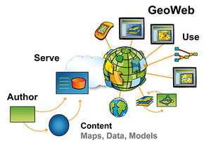
Si bien los primeros 10 años de cartografía en la Web fueron muy importantes, los próximos cinco prometen una revolución total conforme se pasa de la etapa de creación sencilla de mapas y visualización geoespacial hacia la de geoservicios completos en la Web diagram of the GeoWeb, click to enlarge(lo que a veces se denomina "GeoWeb"). Para la industria de sistemas de información geográfica (SIG), la GeoWeb permite el uso compartido y exhaustivo de mapas y datos, y el acceso universal a aplicaciones SIG.
Para leer todo el artñiculo, pincha aquí
lunes, 20 de abril de 2009
Korea Land Corporation Builds Federated GIS with ArcGIS Server
Caso de éxito de ArcGIS Server sobre el SIG de los usos de suelo de Corea.
Recogido de Directions Magazine.
http://www.directionsmag.com/article.php?article_id=3126
geofumadas » Blog Archive » 2 buenas Geofumadas y otras al vuelo
geofumadas » Blog Archive » 2 buenas Geofumadas y otras al vuelo
Fantasticas Geofumadas (Como todas) de este incansable Blogger de los SIG.
Una sobre: Blom, Inteligencia Visual.
Otra sobre: Phidias, un poco más allá de la fotogrametría.
http://galvarezhn.cartesianos.com/2009/04/17/2-buenas-geofumadas-y-otras-al-vuelo/
Fantasticas Geofumadas (Como todas) de este incansable Blogger de los SIG.
Una sobre: Blom, Inteligencia Visual.
Otra sobre: Phidias, un poco más allá de la fotogrametría.
http://galvarezhn.cartesianos.com/2009/04/17/2-buenas-geofumadas-y-otras-al-vuelo/
jueves, 16 de abril de 2009
Virtual Earth actualiza sus API TecnoMaps.com

Virtual Earth actualiza sus API TecnoMaps.com
Recogido de TECNOMAPS
Última actualización de las API de Virtual Earth, más precisamente a los controles de Virtual Earth AJAX y de Virtual Earth 3D map control.
Keep Your Mobile Workforce on Route with ArcLogistics Navigator
ESRI Podcast Series #26
Recogido de Directions Magazine
Kerry Somerville, product manager for navigation at ESRI, discusses how ESRI's ArcLogistics Navigator, an in-vehicle navigation solution, ensures that the efficiencies created with ArcLogistics desktop occur as planned in the field by allowing route planners and dispatchers to provide preoptimized stops to drivers.
Pincha aquí para escucharlo.
lunes, 13 de abril de 2009
The ESRI Dev Summit Keynote video
Recogido de AnyGeo - A GISuser Blog
SOAP vs. REST: Complements or Competitors? Chappell has keynoted events worldwide including the Software Development Conference, Microsoft TechEd events, and many others. Chappell’s books have been published in a dozen languages and used in courses at MIT, ETH Zurich, and other universities. Check it out.. an awesome presentation!
http://www.esri.com/events/devsummit/sessions/keynote.html
Novedades sobre ArcPad 8
ESRI's ArcPad 8 Features Improved Customization and User Interface
Edits to Geodatabase Can Now be Synced via ArcGIS Server.
Por fin ArcPad, puede trabajar online con los elementos de la Geodatabase, a traves de ArcGIS Server. Ya no se necesita esperar a regresar a un puesto desktop de la oficina para actualizar las ediciones realizadas en campo.
www.esri.com/arcpad.
The Role of GIS in Renewable Energy Development
ESRI Podcast Series #25
Mitchell Garnett, ESRI's electric utility industry solutions manager, discusses how GIS can be used in the growth and integration of renewable energy generation. Garnett explains how the ModelBuilder application in ArcGIS can accelerate and simplify the process of assessing potential areas for wind energy generation.
Para escucharlo, pinchar aquí.
Keep Your Mobile Workforce on Route with ArcLogistics Navigator
ESRI Podcast Series #26
Recogido de Directions Magazine
Kerry Somerville, product manager for navigation at ESRI, discusses how ESRI's ArcLogistics Navigator, an in-vehicle navigation solution, ensures that the efficiencies created with ArcLogistics desktop occur as planned in the field by allowing route planners and dispatchers to provide preoptimized stops to drivers.
Para escucharlo, pincha aquí.
Successful Franchising Today Using GIS
ESRI Podcast Series #27
Simon Thompson, ESRI’s commercial business industry solutions director, discusses the role of GIS in successful franchising and the different solutions ESRI provides to assist businesses looking to expand at a profitable pace.
Para escucharlo, pincha aquí.
lunes, 30 de marzo de 2009
Flightmapping
La Cartoteca » Blog Archive » Flightmapping
Flightmapping
Como bien indican en su about us, Flightmapping no pertenece a una línea aérea, ni tiene relación con un aeropuerto determinado, ni siquiera guarda conexión alguna con agentes de viajes. Lo suyo es, sencillamente, proveer unos mapas muy sencillos con información sobre líneas aéreas.
Vía La Cartoteca
Si te has perdido la ESRI Developers Summit 09, aquí tienes los vídeos

Imperesionante vídeo de presentación, y temas tratados.
2009 ESRI Developer Summit
March 23–26, 2009
Wyndham Hotel & Palm Springs Convention Center
Palm Springs, CA
Pincha aquí
Nueva página web para la UC de ESRI Inc. 2009

Como todos los años ESRI se renueva y se complace en unirse a todos sus usuarios a nivel mundial en un evento cada vez más sorprendente:
Este años tiene como lema: GIS—Designing Our Future.
Se realizará en San Diego del 13 al 17 de julio de 2009
Y esta es la invitación que veremos accediendo a la página:
Join us July 13–17, 2009, at the San Diego Convention Center in California.
A destacar el vídeo de presentación protagonizado por el mismo Jack Dangermond.
Saludos
Virtual Earth actualiza 21 TB de imágenes

geofumadas » Blog Archive » Virtual Earth actualiza 21 TB de imágenes
Comentamos este aumento de información dentro del Virtual Earth, ya que nos es muy grato comprobar que toda esto es accesible desde ArcGIS, como Servicios Online "ArcGIS Online" y desde aplicaciones desarrolladas para ArcGIS Server, etc...
Más información en: http://www.esri.es/index.asp?pagina=935
y en: http://www.esri.com/software/arcgis/arcgisonline/premium_map_services.html
El Blog geofumadas, se hace eco de las novedades de ArcGIS

geofumadas » Blog Archive » Geomática, otras novedades: "Acceso a Mundos Virtuales
* Acuerdo de Microsoft y ESRI permite que se pueda acceder a los datos de Virtual Earth desde ArcGIS Desktop o aplicaciones construidas con el SDK de ESRI, incluidos JavaScript, Flex y Silverlight. Con GoogleEarth… nada aún.
* Por su parte Safe Software, ha anunciado que FME podrá acceder a datos de OpenStreetMap, lo que implicaría un paso importante en la vinculación de datos que voluntariamente cerca de 50,000 usuarios han aportado y continuarán haciendo. Ojalá y se sumen a esta alternativa otras herramientas más popularizadas que FME."
jueves, 26 de marzo de 2009
Descargate el nuevo API silverlight para ArcGIS Server. GRATIS

Hasta que no este en versión comercial, el nuevo API de ArcGIS Server para Silverlight de Microsoft es totalmente gratuito para su descarga.
No pierdas la oportunidad de estar a la ultima con esta nueva posibilidad de desarrollo, para hacer las aplicaciones mas vistosas y útiles de todo el cirber-espacio.
Pincha aquí y descárgate el API "GRATUITAMENTE" si tienes una cuenta global de ESRI.
Si no la tienes te la puedes hacer totalmente gratis pinchando aquí.
James Fee GIS Blog » Blog Archive » 2009 ESRI Developer Summit Plenary Session

James Fee GIS Blog » Blog Archive » 2009 ESRI Developer Summit Plenary Session: "2009 ESRI Developer Summit Plenary Session"
Interesante comentario de James Fee sobre la sesión plenaria de la conferencia de Desarrolladores de ESRI Inc.
http://www.spatiallyadjusted.com/2009/03/24/2009-esri-developer-summit-plenary-session/
martes, 24 de marzo de 2009
Nuevo Seminario Completamente Libre de ESRI Inc.
GIS training by a technical expert streamed directly to your desktop. Live Training Seminars are live, interactive, and free. Find out more.
Serving and Managing Imagery with ArcGIS Server
Imagery comes in many different formats and sizes. This live training seminar will focus on how to leverage ArcGIS Server and the ArcGIS Server Image Extension with these various image formats. Topics will include image formats, how ArcGIS handles imagery, scenarios encountered when serving imagery, and best practices for serving your own imagery to both local area networks and the Internet.
lunes, 23 de marzo de 2009
Novedades de ArcGIS Explorer 900

En la sesión plenaria de la Busines Partner Conference, Jack Dangermond habla de las novedades que trae la versión 900 de ArcGIS Explorer y su nuevo foco funcional y de negocio.
Pincha aquí para saber más.
The ArcGIS API for Microsoft Silverlight™/WPF™ is available as a public BETA product - version 1.0 BETA released March 2009.
La versión Beta del API Silverlight para ArcGIS Server ya esta disponible para su descarga gratuita.
Y en esta URL: http://resources.esri.com/arcgisserver/apis/silverlight/ podéis utilizar una pequeña demo, muy pero que muy interesante.
Saludos
Y en esta URL: http://resources.esri.com/arcgisserver/apis/silverlight/ podéis utilizar una pequeña demo, muy pero que muy interesante.
Saludos
NASA applies GIS to its inner spaces
Interesante articulo sobre como la NASA aplica los SIG de ESRI en este proyecto en dos grandes fases:
The first step was accomplished by developing an Extensible Markup Language schema to pull in data from numerous sources. Ball said the XML schema reduced the data preparation time for bringing in datasets from as much as two weeks of intensive effort to an automated process that takes approximately 30 minutes.
The second step was accomplished by connecting the data to the visualization tools offered by ESRI's ArcGIS application.
"We could run the optimization algorithms against nothing else other than Excel data if we chose to," Ball said. "The real power of that is getting that in front of a vast array of managers so that they can understand what the possible scenarios are and what the impacts on their organizations can make. The visualization tools that ESRI provides give this incredible power."
Para leer el articulo completo, pincha aquí.
Nuevo Blog sobre ArcGIS Business Analyst
Todos los que estamos interesados en la aplicación de los Sistemas de Información Geográfica a los negocios estamos de celebración.
Pues tenemos un nuevo medio por el cual podremos ver las últimas tendencias y novedades que ArcGIS Business Analyst nos ofrece para poder aplicarlo a nuestro trabajo cotidiano.
Para saber más:
http://blogs.esri.com/Dev/blogs/businessanalyst/default.aspx
Pues tenemos un nuevo medio por el cual podremos ver las últimas tendencias y novedades que ArcGIS Business Analyst nos ofrece para poder aplicarlo a nuestro trabajo cotidiano.
Para saber más:
http://blogs.esri.com/Dev/blogs/businessanalyst/default.aspx
Navegando me he encontrado esta noticia sobre un seminario que nos puede ayudar a mejorar la experiencia de usuario en nuestros desarrollos de aplicaciones web para ArcGIS Server + Web 2.0
SEMINARIO SOBRE 'MEJORES ESTRATEGIAS DE DISEÑO GUI Y WEB 2.0'
Se trata de un curso donde se presentará los resultados de últimas investigaciones en el campo del diseño de aplicaciones y usabilidad o cómo implementar técnicas de interacciones y uso para aumentar la satisfacción y experiencia del usuario.
Asimismo, el seminario incluye el código fuente demo que utiliza las técnicas más modernas y avanzadas, en especial, las relacionadas con la Web 2.0 y todo lo referente a la integración Windows – Web, un campo con gran potencial en el desarrollo corporativo de aplicaciones.
Más información
viernes, 20 de marzo de 2009
Lector de tarjetas con recuperación de fotos borradas
Lector de tarjetas con recuperación de fotos borradas
Por si os pasa lo que a mí, que pierdo las fotos o las borro sin querer.
Lector de tarjetas con recuperación de fotos borradas
Versión para imprimir
Transcend ha presentado un lector de tarjetas de memoria que incluye herramientas de recuperación de imágenes y datos perdidos.
No es una sorpresa agradable ir a ver las fotos de las vacaciones y descubrir que se han borrado accidentalmente o la tarjeta se ha estropeado y los datos son ilegibles. Para estos casos Transcend ha presentado el lector de tarjetas P8 USB que se acompaña de software de recuperación de archivos.
El programa dispone de una interfaz sencilla que permite buscar en la tarjeta de memoria los rastros de archivos borrados para poder recuperarlos. Además de recuperar imágenes borradas accidentalmente, la herramienta de recuperación de fotos sirve también para documentos, vídeos, hojas de cálculo, música y cualquier otro tipo de archivo.
Lector de tarjetasEl lector de tarjetas P8 USB de Transcend soporta transferencias de alta velocidad Ultra DMA, admitiendo tarjetas CompactFlash 300X. Se trata de un lector multiformato que admite las tarjetas más habituales como las CF, SD, SDHC, MMC, MMCplus, RS-MMC, MMCmobile, microSD, microSDHC y las series de memory stick de Sony.
El precio del lector de tarjetas P8 USB de Transcend, que se fabrica en blanco y en negro, es de 9,28 €.
viernes, 13 de marzo de 2009
Virtual Earth añadió 55 TB de datos en Febrero TecnoMaps.com
Virtual Earth añadió 55 TB de datos en Febrero TecnoMaps.com
Es para tener en cuenta, ya que es el servicio de imágenes con mejor detalle del mercado.
Sabiendo que está integrado dentro de los servicios de ArcGIS Online y que está integrado con ArcGIS.
Para saber más.
Es para tener en cuenta, ya que es el servicio de imágenes con mejor detalle del mercado.
Sabiendo que está integrado dentro de los servicios de ArcGIS Online y que está integrado con ArcGIS.
Para saber más.
jueves, 12 de marzo de 2009
ArcGIS Server JavaScript API Posts « GeoChalkboard
ArcGIS Server JavaScript API Posts « GeoChalkboard
Listado de posts sobre el API JavaScript de ArcGIS Server y como realizar Mashups con Google Maps
Listado de posts sobre el API JavaScript de ArcGIS Server y como realizar Mashups con Google Maps
3-GIS Uses ESRI's ArcGIS API for Flex to Create Browser-Based Engineering Solution
Speaker Series Podcast: 3-GIS Uses ESRI's ArcGIS API for Flex to Create Browser-Based Engineering Solution
de ESRI News Feed
Danny Hatcher, senior software engineer for 3-GIS, an ESRI business partner, introduces Network Express, a browser-based engineering solution built on ESRI's ArcGIS Server technology, including the ArcGIS API for Flex. Network Express allows users to plan, design, and manage their GIS asset data within a work order environment utilizing the Internet.
Si no puedes escucharlo, pincha aquí
Introduction to ArcGIS Engine Functionality de ESRI Instructional Series
Introduction to ArcGIS Engine Functionality
de ESRI Instructional Series
This discussion is a follow-up to a previous podcast titled Introduction to ArcGIS Engine Development. This podcast will introduce ArcGIS Engine’s core functionality and how it can be used to execute advanced or specialized GIS applications. This podcast is intended for developers who want to investigate how ArcGIS Engine can be used to create a wide range of applications.
lunes, 9 de marzo de 2009
Historico: Alfonso Rubio Consejero Delegado de ESRI España, Mesa Redonda en IGN
 Image by earthhopper via Flickr
Aquí podrás acceder a los casos de éxito de ESRI España
![Reblog this post [with Zemanta]](http://img.zemanta.com/reblog_e.png?x-id=0d18dbd2-9afa-43ad-92dc-ef0529310691)
jueves, 5 de marzo de 2009
Speaker Series Podcast: 2009 ESRI Developer Summit: Programming and Design Patterns for the ArcGIS Mobile API

"Speaker Series Podcast: 2009 ESRI Developer Summit: Programming and Design Patterns for the ArcGIS Mobile API de ESRI News Feed
http://www.esri.com/news/podcasts/audio/speaker/staff_barrera_chen.mp3
Interesante podcast sobre el API de ArcGIS Mobile.
Sabine Barrera and Jay Chen, product engineers, provide an overview of the Programming and Design Patterns for the ArcGIS Mobile API session that they will present at the upcoming 2009 ESRI Developer Summit, March 23-26 in Palm Springs, California. This session will cover key features of the ArcGIS Mobile SDK and describe in detail what developers need to know to write effective mobile applications for ArcGIS Server."
miércoles, 4 de marzo de 2009
Google Street View añade imágenes de Panoramio TecnoMaps.com

Google Street View añade imágenes de Panoramio
Interesante articulo recogido de TecnoMaps:
Google Street View, el servicio de vistas de calle integrado en Google Maps, ha comenzado a añadir imágenes aportadas por los usuarios a través de Panoramio. Gran noticia sin dudas, puesto que las imágenes de la capa de Panoramio ofrecen una resolución mucho mayor, además de contar con imágenes diurnas y nocturnas de un mismo punto, como así también de verano e invierno.
Ahora, entonces, cuando navegamos por los mapas de Google y con las vistas de calle, tenemos en la parte superior de la pantalla las imágenes en miniatura aportadas por los usuarios, que aparece siempre que haya imágenes aportadas por los usuarios. Al hacer click en alguna de ellas, estas se maximizan, permitiéndonos ver con todo detalle.
Si queremos volver a las vistas aportadas por Google hemos de hacer click en la vista miniatura de más a la derecha, que tiene el texto de Street View en blanco debajo de ella. Eso si, no esperemos ver todas las imágenes que han sido publicadas en Panoramio, ya que Google recibe las fotos que los usuarios envían y las someten siempre a un estricto control para verificar que estas se ajusten a las reglas. Las que aprueben, a partir de ahora serán consideradas para su inclusión en Google Street View, y luego se les eliminarán los datos personales, matrículas de coches, etc
martes, 3 de marzo de 2009
ESRI TV, el canal de TV de ESRI en YouTube.

ESRI abre este nuevo canal al alcance de todo el mundo, utilizando las redes sociales y en concreto los canales de publicación de YouTube. En él se compartirán vídeos sobre ArcGIS, el SIG de ESRI, que le ayudarán a tomar mejores decisiones a través de modelos y la creación de mapas. ESRI TV presentará vídeos sobre, por ejemplo, la gestión más eficiente de datos, herramientas cartográficas mejoradas, y mejores métodos para compartir la información. Contiene unos 50 vídeos en una gran variedad de temas sobre ArcGIS y el contenido es actualizado periódicamente.
Para conectarse a este canal solo tiene que pinchar en http://www.youtube.com/esritv.
Puede acceder también a los vídeos a través de Viddler: http://www.viddler.com/explore/esri
Y si quiere recibir notificación RSS cada vez que se publique un nuevo vídeo, solo debe de suscribirse a través de esta url: http://www.youtube.com/rss/user/esritv/videos.rss
lunes, 2 de marzo de 2009
Avalon se incorpora al programa de partners de ESRI España - Noticias
Avalon se incorpora al programa de partners de ESRI España
Avalon se incorpora al programa de ‘partners’ de ESRI España - Noticias - ChannelInsider.es
Avalon se incorpora al programa de ‘partners’ de ESRI España - Noticias - ChannelInsider.es
viernes, 27 de febrero de 2009
Nuevo canal YouTube de ESRI España
En el hemos subido como prueba, un vídeo introductorio a ArcGIS Business Analyst.
Espero que os guste.
miércoles, 25 de febrero de 2009
ESRI PONE EN MARCHA EL SISTEMA GEODOCUMENTAL DE SANTIAGO DE COMPOSTELA

La plataforma tecnológica de ESRI servirá para visualizar y analizar la información cartográfica de la parte antigua de Santiago de Compostela
A partir de 2010 el sistema permitirá las visitar virtuales a un recinto declarado Patrimonio de la Humanidad
En el proyecto ha participado ATOS ORIGIN como integrador.
Para leer la nota de prensa completa, pinchar aquí.
European Commission Awards INSPIRE@EC Contract to ESRI Technology-Based Consortium

Contract Covers Development of GIS Technical Components for a Spatial Data Infrastructure.
NOTICIA IMPORTANTE:
La Comisión Europea otorga el proyecto INSPIRE a un consorcio de empresas basado en tecnología ESRI
La idea principal del contrato se basa en el desarrollo de los componentes SIG para el geoportal INSPIRE.
La Oficina de Estadística de la Comisión Europea (Eurostat) ha otorgado el contrato de la iniciativa INSPIRE@EC a un consorcio de empresas que han basado la solución en tecnología ESRI. El contrato consiste en el desarrollo de componentes técnicos de la IDE para la Comisión Europea siguiendo las especificaciones INSPIRE.
Para saber más pincha aqui: http://www.esri.com/news/releases/09_1qtr/european_commission.html
martes, 24 de febrero de 2009
Nuevo ArcGIS para AutoCAD built 200
Aquí tenéis un video-demo de como funciona la extensión gratuita de ESRI para AutoCAD, con la cual podremos conectarnos a servicios SIG de ArcGIS Server.http://vid01.esri.com/winmmedia/autocad_09.wmv
En esta nueva versión se ha conseguido que la interoperabilidad sea tal que los datos en su formato original pueden ser utilizados por ambas aplicaciones.
ArcGIS para AutoCAD de ESRI de descarga libre ha mejorado radicalmente la facilidad con la que los usuarios pueden compartir y usar contenidos de los sistemas de información geográfica (SIG) con archivos de AutoCAD manteniendo los circuitos de producción de CAD. ArcGIS para AutoCAD Build 200 ofrece interoperabilidad fácil; que da a acceso a los usuarios de AutoCAD a datos SIG de empresa e imágenes publicadas con ArcGIS Server dentro del entorno de trabajo de AutoCAD. También proporciona medios para preparar datos de AutoCAD para su uso en ArcGIS.
ArcGIS para AutoCAD Build 200 soporta los servicios de mapa cacheados de ArcGIS Server 9.3, servicios de mapa de ArcGIS Server sobre servidores seguros, y el contenido disponible de servicios de mapa libres y premium disponible desde ArcGIS online service.
Más información en: http://www.esri.com/software/arcgis/arcgis-for-autocad/index.html
Portales IDEE creados con tecnología de ESRI

Aquí podéis encontrar un pequeños listado de portales IDEE que ofrecen servicios WMS, publicados con software ArcGIS Server de ESRI.
Pincha aquí para leer más sobre ellos:
http://www.esri.es/img/ides/REFERENCIAS_PORTALES_SOFT_ESRI.htm
Blog IDEE: WMS del Ayuntamiento de Madrid
Blog IDEE: WMS del Ayuntamiento de Madrid
Publicado recientemente un fantástico Servicio Web de Mapas (WMS) del Ayuntamiento de Madrid rápido, con una simbología moderna y con una gran cantidad de información, detallada y exhaustiva.
Este servicio se ha publicado con la tecnología ArcGIS de ESRI.
Compruébalo pinchando aquí: http://www-1.munimadrid.es/wmsconnector/com.esri.wms.Esrimap/SIGMA2005_WMS_INV lo puedes visualizar con cualquier visor que consuma servicios estandarizados WMS.
Saludos
lunes, 23 de febrero de 2009
James Fee GIS Blog » Blog Archive » The least surprising news of the week - ArcGIS API for Microsoft Silverlight (Coming Soon)
James Fee GIS Blog » Blog Archive » The least surprising news of the week - ArcGIS API for Microsoft Silverlight (Coming Soon)
ARCGIS FOR SILVERLIGHT, NUEVA VERSIÓN......
EN DOS PALABRAS IM - PRESIONANTE....
ARCGIS FOR SILVERLIGHT, NUEVA VERSIÓN......
EN DOS PALABRAS IM - PRESIONANTE....
Concepts - ArcGIS API for Flex
Concepts - ArcGIS API for Flex
NUEVA VERSIÓN DEL API DE FLEX DE ARCGIS SERVER 1.1.
NUEVA VERSIÓN DEL API DE FLEX DE ARCGIS SERVER 1.1.
jueves, 19 de febrero de 2009

ESRI España participa como expositor en Globalgeo y realiza una jornada especial el día 4
Nuestra participación tendrá lugar durante el Salón Internacional de la Geomática y Geotelemática, que se celebrará del 3 al 5 de marzo de 2009 en el Palacio de Congresos de Feria de Barcelona, en el recinto de Montjuïc.
Comprueba la Agenda de nuestras conferencias dentro de GlobalGeo
viernes, 6 de febrero de 2009
How GIS Aids Local Government and First Responders in Crises
Interesante articulo de como los SIG ayudan en los Desastres naturales y Emergencias.
http://www.pti.org/index.php/ptiee1/more/445/
También os podéis descargar el pdf
Saludos
http://www.pti.org/index.php/ptiee1/more/445/
También os podéis descargar el pdf
Saludos
Rsc. una empresa espanola creará en namibia la primera licenciatura de geo-información - 5/02/09 - EcoDiario.es
Rsc. una empresa espanola creará en namibia la primera licenciatura de geo-información - 5/02/09 - EcoDiario.es
Noticia muy interesante sobre el proyecto de Nanibia, desarrollado por ESRI España para el Gobierno de dicho país.
Saludos
Noticia muy interesante sobre el proyecto de Nanibia, desarrollado por ESRI España para el Gobierno de dicho país.
Saludos
miércoles, 4 de febrero de 2009
Twitter / Home
Twitter / Home: "Speaker Series Podcast: Health Data Standards Chair Sees Spatial Data as Essential Contributor to Understanding .. http://tinyurl.com/brr6q3 cerca de 21 horas ago from twitterfeed"
Nuevo Podacast sobre los SIG en el sector Sanidad y Sanitario.
http://www.esri.com/news/podcasts/audio/speaker/user_hammond.mp3
Nuevo Podacast sobre los SIG en el sector Sanidad y Sanitario.
http://www.esri.com/news/podcasts/audio/speaker/user_hammond.mp3
martes, 3 de febrero de 2009
Penetración de experiencias SOA por sectores de actividad - Computing

Penetración de experiencias SOA por sectores de actividad - Computing
Interesante articulo sobre la integración de las Arquitecturas Orientadas a Servicios (SOA) por sector.
Los SIG no son una excepción y desde ESRI también estamos trabajando con estos conceptos, ver foto:
Para saber más ponte en contacto en informacion@esri.es.
Microsoft amplia su acuerdo global con Navteq - Computing
Microsoft amplia su acuerdo global con Navteq - Computing: "La ampliación del acuerdo que mantiene desde hace una década con Navteq permite a Microsoft acceder a la cartografía de los 74 países que cubre la BBDD de Navteq, además de poder utilizar sus plataformas Transport, Discover Cities y Voice."
Microsoft vuelve ahora a ampliar este acuerdo global, consiguiendo acceso a la totalidad de una base de datos cartográfica que cubre 74 países, además de poder utilizar las plataformas Navteq Transport, Navteq Discover Cities y Navteq Voice; así como el producto Extended Listings, que incluye cientos de miles de catálogos para la personalización de categorías y la optimización de la selección de destinos.
Microsoft vuelve ahora a ampliar este acuerdo global, consiguiendo acceso a la totalidad de una base de datos cartográfica que cubre 74 países, además de poder utilizar las plataformas Navteq Transport, Navteq Discover Cities y Navteq Voice; así como el producto Extended Listings, que incluye cientos de miles de catálogos para la personalización de categorías y la optimización de la selección de destinos.
Google Reader (1000+)
Google Reader (1000+)
Me uno a la celebración del lanzamiento de la mayor revista digital del sector SIG, ahora en Castellano.
http://www.directionsmag.es/
Desde ESRI España colaboraremos con información de producto, formación, seminarios, servicios y mucho más.
También me agrada ver que los Blogs relacionados son muchos de los que yo visito diariamente.
Saludos a Gabriel Ortiz, que me recordará de nuestras conversaciones cuando fui el comercial de ESRI asignado a la cuenta del Gobierno de Cantabria.
Geofumadas, el cual admiro por su dedicación y diversificación de contenidos.
Y otro que ya iré comentando a lo largo de este mes.
Saludos a todos
miércoles, 28 de enero de 2009
Google Reader (1000+)
Google Reader (1000+)
http://www.esri.es/index.asp?pagina=1042
Nuevo Podcast de cómo los Bancos e Instituciones Financieras emplean el SIG para salir a flote durante las épocas de crisis
Shelli Stockton, finance and banking industry manager de ESRI, reflexiona a cerca de cómo las instituciones financieras y bancos de diversa índole e ingresos, emplean el SIG en épocas de crisis para ayudar a optimizar sus acciones y recursos.
lunes, 12 de enero de 2009
Press Release -- Michael Gould Joins ESRI's Education Team
Press Release -- Michael Gould Joins ESRI's Education Team
Michael Gould se une a ESRI como director del sector educación.
Es un placer contar con una persona de su categoria y profesionalidad.
Desde ESRI España le damos la bienvenida y nos ponemos a su disposición.
Saludos y buena suerte.
Michael Gould se une a ESRI como director del sector educación.
Es un placer contar con una persona de su categoria y profesionalidad.
Desde ESRI España le damos la bienvenida y nos ponemos a su disposición.
Saludos y buena suerte.
Suscribirse a:
Entradas (Atom)