En este blog encontraras cosas tan dispares como productos, eventos y alguna curiosidad que encuentro, relacionado con los SIG en mi trabajo diario. También curiosidades y aficiones personales, como el AIKIDO, Mountain Bike, etc...
jueves, 30 de abril de 2009
Bueno Señores creo que por esta semana ya está bien
Hoy mismo empiezo mi merecido puente, y dejo los GIS aparcados hasta el lunes.
Tengo en mente publicar algo sobre ArcGIS Portal Tool Kit para desktop, pero eso será el lunes.
Me voy a ver a mi hijo y a disfrutar de él.
miércoles, 29 de abril de 2009
ArcGIS 9.3.1 Unlocks the Potential of Your GIS
Ya empieza a aparecer más información sobre la versión de ArcGIS 9.3.1
ArcGIS 9.3.1 Unlocks the Potential of Your GIS
Redlands, California—April 27, 2009 — ArcGIS 9.3.1, which began shipping today, helps you create and share modern Web maps that are relevant to your entire organization. This release of ESRI's integrated collection of geographic information system (GIS) software products focuses on improving the performance of dynamic map publishing and increasing the visibility of geographic information.
High-Performance Dynamic Map Publishing
ArcGIS 9.3.1 includes an optimized map service that allows you to produce high-performance dynamic maps. The improved map quality in these services includes sharper edges to features, clearer labels, and better color transparency. ArcGIS Desktop users can fine-tune their maps for faster performance using the new Map Service Publishing toolbar. The toolbar allows maps to be analyzed and makes recommendations for fine-tuning. The results can be previewed, and estimated draw times are provided. Maps can now be published directly from the ArcGIS Desktop ArcMap application to ArcGIS Server. Optimized map services also improve map caching performance, as faster rendering speeds reduce the time it takes to create map caches for basemaps. Map quality is noticeably improved, and storage is more efficient. These new map services outperform equivalent ArcIMS services and provide significantly better-looking maps, benefiting those who use dynamic Web mapping or combine dynamic and cached maps on the Web.
Better Sharing of Geographic Information
ArcGIS now includes functionality to allow users to easily share and search for geographic content, such as maps, data, layers, and services. ArcGIS Online includes a new application in which users can create an account and, through a keyword search, find content; preview it; and, with a simple click, add it to ArcMap or ArcGIS Explorer. To facilitate the sharing of layers in ArcGIS, users can create layer packages that encapsulate ArcMap cartography and data, including a thumbnail, the extent, and spatial reference, in an easy-to-share package. Layer packages can be shared via ArcGIS Online as files, attached to e-mails, or included on DVDs. Joining the ArcGIS Online user community is easy and free to all ArcGIS users.
Seamless Integration with Microsoft Virtual Earth
ArcGIS Desktop users are now able to directly connect to Microsoft Virtual Earth services and quickly start their GIS projects with ready-to-use content at no additional charge. Virtual Earth services, which include imagery, streets, and hybrid imagery with street labeling, appear as just another data layer in GIS. Virtual Earth imagery and street maps provide excellent background maps on which users can overlay their operational data. Also, ArcGIS Explorer users and ArcGIS Server developers who are using Microsoft Silverlight, Flex, JavaScript, Java, or .NET now have simple access to the same high-quality Microsoft Virtual Earth basemap data.
ArcGIS API for Microsoft Silverlight
ArcGIS Server now supports Microsoft's Silverlight Web development platform for building fast, highly interactive Web applications. The new ArcGIS API for Microsoft Silverlight allows developers to use any .NET Framework-supported language to add GIS capabilities and consume services from ArcGIS Server and Microsoft Virtual Earth in a Silverlight application. The API takes full advantage of the mapping, geocoding geometry, image, and geoprocessing capabilities of ArcGIS Server. End users can display their data in an interactive map, search for and display GIS data features and attributes, locate addresses, identify features, access raster imagery, and perform complex spatial analysis by simply clicking a button or feature on the map.
Easy to Install
ArcGIS 9.3 users are able to easily upgrade to ArcGIS 9.3.1 without having to uninstall ArcGIS 9.3. In addition, ArcGIS 9.3.1 is completely compatible with ArcGIS 9.3, so users will be able to easily work in mixed environments within the same organization.
Changes to ArcGIS Server Licensing Provide More Flexibility
With the release of ArcGIS Server 9.3.1, some licensing changes have been made to allow users more flexibility in their ArcGIS Server deployments. The editing feature of ArcGIS Server is now available for ArcGIS Server Standard users (previously, editing was only available with ArcGIS Server Advanced). In addition, ArcGIS Server 9.3.1 Advanced includes the Spatial, 3D, Network, and Geostatistical extensions for no additional fee. Finally, to give users more flexibility in their configuration of ArcGIS Server, the Web Application Development Framework (ADF), Web Service Handlers, and Server Object Manager can be deployed on multiple machines without paying an additional deployment license fee.
Resources to Help You Get Started
New sample viewers and templates are available on the ESRI Resource Centers Web site at resources.esri.com to help users get their applications up and running more quickly. Also, ESRI is offering a free seminar, Creating Effective Web Maps, throughout the United States from April 30 through June 9, 2009. This seminar will show users how to take advantage of available resources and learn design strategies for building fast, intuitive Web maps. See www.esri.com/webmaps for seminar details.
To learn more about ArcGIS 9.3.1, visit www.esri.com/whatsnew.
martes, 28 de abril de 2009
Using detailed logging with ArcGIS Server 9.3
Como utilizar un logging detallado con ArcGIS Server 9.3.
Os paso el vínculo al posteo creado en el blog de desarrollo de ArcGIS Server, donde detallan paso por paso como activar un loggin detallado a la hora de pintar elementos en una palicación de mapa creada con ArcGIS Server 9.3 y 9.3.1.
During the initial releases of ArcGIS Server, many users asked for fine-grained logging down to the layer draw level. This functionality was added to ArcGIS Server 9.3 as a new logging level Info:Detailed. The detailed logging is especially helpful when troubleshooting performance. In this post, we’ll consider the scenario that you have a map service that’s not drawing as fast as you’d like.
Here it’s worth noting that before you go to the logs, it may be easier to catch the problem using the popular mxdperfstat tool from ArcScripts or the “Analyze” button on the 9.3.1 Map Service Publishing Toolbar. As ArcGIS Server 9.3.1 becomes available in the next few weeks, we’ll be posting more information about the Map Service Publishing toolbar and how it can quickly point out areas for improvement in your map document. Version 9.3.1 also includes a faster drawing engine for map services that will help improve performance.
When you need more detail about what’s happening during a map draw, you can go to the log files and enable the new detailed logging. This is the workflow you’d follow:
Set the log level to Info:Detailed. If you need help with this step, see Specifying the log file location (skip steps 3 and 4). While you’re looking at the log properties page, note the path to the log file and browse to the log directory in Windows Explorer so you don’t have to hunt around for the file later.
Make a simple request to your map service by zooming or panning. Note the current time so you can find the request in the log.
Examine the log that was created during your request and note the feature count and elapsed draw time of each layer. For this step sometimes it’s helpful to print the log and use a highlighter to note the draw times. You’ll immediately see which layers are taking the longest to draw. Also, keep an eye on the feature count to spot inefficient layers. A layer may take only 0.2 seconds to draw at a particular extent, but if the extent only included 2 features you may have a potential inefficiency.
Repeat this process at several different locations and scales in your map. You want to make sure you analyze a good sample of the symbology and layers in your map.
When you finish, set the log level back to Normal.
The Help topic Map service log codes contains a table of the codes you’ll see when analyzing the detailed logging. If you scroll down the topic you’ll also find an example of the codes returned from a simple ExportMapImage request like the one that happens when you zoom or pan the map.
To learn more about detailed logging and the different log levels, see How log files work.
Contributed by Sterling Quinn of the ArcGIS Server development team
Published Monday, April 27, 2009 11:50 AM by sterlingdq
Filed under: Troubleshooting, Administration, Performance
Australia Energy Company Jemena Focuses on Safety for Infrastructure Management
Pipelines, Electric Network Monitored with GIS Technology from ESRI
Redlands, California—April 27, 2009 — Australian energy infrastructure management company Jemena takes its name from an aboriginal word meaning "to hear, to listen, and to think," and the company uses geographic information system (GIS) technology to do just that for safety management. Using ArcGIS software from ESRI, Jemena can view its assets relative to utility line crossings, land-use zoning, and rights-of-way, as well as critical or sensitive infrastructure such as airports, schools, or hospitals.
Jemena's assets include the Eastern Gas Pipeline, the Queensland Gas Pipeline, and the transmission pipelines serving the Greater Sydney region. With transmission and distribution operations, Jemena supplies gas to over 1.6 million customers in Melbourne and Sydney. The company also supplies electricity to approximately 285,000 homes and businesses in the northwestern area of Greater Melbourne.
"GIS is the tool we use for safety management studies," said Chris Hamilton, GIS manager, Jemena. "With ESRI's ArcMap, we are able to pan along the pipeline to view current and historic threats and monitor changing conditions along the right-of-way. If we discover, for example, a large irrigation ditch crossing the pipeline, we are able to make the best decision to avoid risk to our assets from third-party interference."
ArcMap is one of the core applications delivered with all licensing levels of ESRI's ArcGIS Desktop. With ArcGIS Desktop, users can perform advanced spatial analysis, model operational processes, and visualize results on professional maps.
"ESRI's GIS technology provides data integration capabilities, modeling and analysis tools, and a geographic environment for reporting," said Rob Brook, ESRI's pipeline and gas industry manager. "Jemena is a powerful example of how pipeline operators are using GIS to maintain complex datasets, build comprehensive risk models, and use the results to ensure public safety."
Para saber más de la aplicación de los SIG de ESRI en España, pincha aquí
lunes, 27 de abril de 2009
ArcPAD 8 ya está en la calle.
Ya podemos comprobar cuales son las novedades que nos proporciona el nuevo ArcPAD 8.
De ellas podemos destacar un entorno agradable de desarrollo para personalizar el interface de usuario llamado ArcPad Studio y la total integración de ArcPad con ArcGIS Server, para poder transmitir las ediciones y recopilaciones de datos en campo de una forma más ágil y acorde con las reglas de comportamiento definidas en nuestra Geodatabase.
Highlights de ArcPad 8:
New User Interface
The new ArcGIS Server ArcPad Extension allows users to publish an ArcPad project to ArcGIS Server.
Improved GPS User Interface
Enhanced ArcPad Data Manager Extension
StreetMap Improvements
Para saber más pincha aquí
La 9.3.1 está cada vez más cerca
Cuando aún nos estamos acostumbrando al Service Pack 1 de la versión de ArcGIS 9.3.
Ya nos están informando de las novedades que traerá la nueva versión que se llamará ArcGIS 9.3.1.
Es muy posible que a finales del Q2 o a primeros del Q3 ya esté disponible para nuestro país.
Esta versión trae múltiples novedades que iremos contando poco a poco.
Para empezar a abrir boca, podéis conectaros a la página de ESRI Inc. donde ya detallan las mejoras de esta
"release".
http://www.esri.com/software/arcgis/whats-new/index.html
Los SIG y la GeoWeb - Articulo de Jack Dangermond
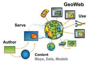
Si bien los primeros 10 años de cartografía en la Web fueron muy importantes, los próximos cinco prometen una revolución total conforme se pasa de la etapa de creación sencilla de mapas y visualización geoespacial hacia la de geoservicios completos en la Web diagram of the GeoWeb, click to enlarge(lo que a veces se denomina "GeoWeb"). Para la industria de sistemas de información geográfica (SIG), la GeoWeb permite el uso compartido y exhaustivo de mapas y datos, y el acceso universal a aplicaciones SIG.
Para leer todo el artñiculo, pincha aquí
lunes, 20 de abril de 2009
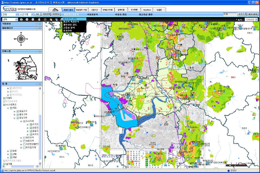
Korea Land Corporation Builds Federated GIS with ArcGIS Server
Caso de éxito de ArcGIS Server sobre el SIG de los usos de suelo de Corea.
Recogido de Directions Magazine.
http://www.directionsmag.com/article.php?article_id=3126
geofumadas » Blog Archive » 2 buenas Geofumadas y otras al vuelo
Fantasticas Geofumadas (Como todas) de este incansable Blogger de los SIG.
Una sobre: Blom, Inteligencia Visual.
Otra sobre: Phidias, un poco más allá de la fotogrametría.
http://galvarezhn.cartesianos.com/2009/04/17/2-buenas-geofumadas-y-otras-al-vuelo/
Fantasticas Geofumadas (Como todas) de este incansable Blogger de los SIG.
Una sobre: Blom, Inteligencia Visual.
Otra sobre: Phidias, un poco más allá de la fotogrametría.
http://galvarezhn.cartesianos.com/2009/04/17/2-buenas-geofumadas-y-otras-al-vuelo/
jueves, 16 de abril de 2009
Virtual Earth actualiza sus API TecnoMaps.com
Recogido de TECNOMAPS
Última actualización de las API de Virtual Earth, más precisamente a los controles de Virtual Earth AJAX y de Virtual Earth 3D map control.
Keep Your Mobile Workforce on Route with ArcLogistics Navigator
ESRI Podcast Series #26
Recogido de Directions Magazine
Kerry Somerville, product manager for navigation at ESRI, discusses how ESRI's ArcLogistics Navigator, an in-vehicle navigation solution, ensures that the efficiencies created with ArcLogistics desktop occur as planned in the field by allowing route planners and dispatchers to provide preoptimized stops to drivers.
Pincha aquí para escucharlo.
lunes, 13 de abril de 2009
The ESRI Dev Summit Keynote video
Recogido de AnyGeo - A GISuser Blog
SOAP vs. REST: Complements or Competitors? Chappell has keynoted events worldwide including the Software Development Conference, Microsoft TechEd events, and many others. Chappell’s books have been published in a dozen languages and used in courses at MIT, ETH Zurich, and other universities. Check it out.. an awesome presentation!
http://www.esri.com/events/devsummit/sessions/keynote.html
Novedades sobre ArcPad 8
ESRI's ArcPad 8 Features Improved Customization and User Interface
Edits to Geodatabase Can Now be Synced via ArcGIS Server.
Por fin ArcPad, puede trabajar online con los elementos de la Geodatabase, a traves de ArcGIS Server. Ya no se necesita esperar a regresar a un puesto desktop de la oficina para actualizar las ediciones realizadas en campo.
www.esri.com/arcpad.
The Role of GIS in Renewable Energy Development
ESRI Podcast Series #25
Mitchell Garnett, ESRI's electric utility industry solutions manager, discusses how GIS can be used in the growth and integration of renewable energy generation. Garnett explains how the ModelBuilder application in ArcGIS can accelerate and simplify the process of assessing potential areas for wind energy generation.
Para escucharlo, pinchar aquí.
Keep Your Mobile Workforce on Route with ArcLogistics Navigator
ESRI Podcast Series #26
Recogido de Directions Magazine
Kerry Somerville, product manager for navigation at ESRI, discusses how ESRI's ArcLogistics Navigator, an in-vehicle navigation solution, ensures that the efficiencies created with ArcLogistics desktop occur as planned in the field by allowing route planners and dispatchers to provide preoptimized stops to drivers.
Para escucharlo, pincha aquí.
Successful Franchising Today Using GIS
ESRI Podcast Series #27
Simon Thompson, ESRI’s commercial business industry solutions director, discusses the role of GIS in successful franchising and the different solutions ESRI provides to assist businesses looking to expand at a profitable pace.
Para escucharlo, pincha aquí.
Suscribirse a:
Entradas (Atom)
Comparte en Facebook
Mi gran Blogg: